 |
| Acadia at Schoodic Peninsula - View towards Mt. Desert Island |
I am up and out of the hotel by 8:45. It is cold outside, 25 degrees. I am most thankful that the LL Bean Outlet was open last evening. My newly purchased long underwear are doing their job well this morning. The sky is blue, not a cloud in sight. The smiles begin. I grab a cup of steaming coffee and head out. My plan is to drive up the coast on US 1, taking side trips to specific places of interest along the way. I love days like today, with no set itinerary, no set time frame, exploring where I please when I please.
 |
| Ruth & Wimpie's |
 |
| Carter's Beach Road - Hancock Point |
I follow the road back up the peninsula to US 1 again, and continue my trek north, or way down east, as they say. I see a sign for Tidal Falls Preserve and veer off the highway once again. How can I ignore a sign for falls? I find myself at Frenchman’s Bay Conservancy at Tidal Falls - or Sullivan Falls, as they are also called, where I learn about reversing falls.
 |
| Sullivan Falls |
 |
| Common Eider (not my photo) |
The birds appear to be the Common Eider, stocky, thick-necked birds, the largest duck in the northern hemisphere. I think they are beautiful. They are too far away to photograph well, but I enjoy what I see. Then my fingers and my nose begin to freeze, and I decide to move on.
As I travel I realize that this part of the coast is composed of fingers, fingers of land jutting into the sea, as the sea in turn grasps the edges of the land with its own. I occasionally glimpse the water and far islands from US 1, but to get to the edge of the water I must travel down the side roads, down the fingers, which is my plan. My next stop is to be the section of Acadia National Park that is located on Schoodic Peninsula.
 |
| Acadia at Schoodic Peninsula |
 |
| Icy water, Acadia at Schoodic Peninsula |
Soon I enter Acadia National Park at Schoodic Peninsula, and I am thrilled at what I find. A one-way road runs along the coast, bounded on one side by spruce-fir forest, by the waters of Frenchman’s Bay on the other. Across the Bay I see Acadia, including Cadillac Mountain, and the Prospect Harbor Lighthouse. The shore here is composed of rocky outcroppings of pink or red granite. It is so cold that I pass one inlet that is partially iced over. A two-way road branches off and takes me to Schoodic Point and the Schoodic Education and Research Center.
 |
| Diabase dike on left |
This area is fairly isolated, and I see few other adventurers. Continuing on the one-way road, I stop at beaches composed of cobblestones and smaller rounded rocks in rainbow hues. In the distance are forested islands edged by granite, all tinged blue in the cold winter day. Though I, too, am tinged blue by the frigid temperature, I cannot resist exploring this marvelous land. I wander among the cobblestones, atop the outcroppings, and beside the water. I find myself breathing a bit more slowly and a bit deeper. I lose track of time. I enter a relaxed state that seems to come to me on days like today, when I am given the opportunity to explore the natural world. It is restorative.
I return to US 1 and head north again, passing through some fairly bleak landscape dotted by small villages: Goldsboro - more homes with boats, traps and buoys; Steuben; Millbridge. The village of Cherryfield boasts itself to be the Blueberry Capital of the World, and I realize that the barren fields of bushes along the side of the road are wild blueberries!
 |
| Worcester Wreath Company |
 |
| Wild Blueberry Bushes - Roque Bluffs State Park |
 |
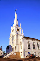
| Centre Street Congregational Church - Machias |
 |
| First Congregational Church East Machias |
Eastport appears rather quaint, and I want to explore further. I stop in at Raye’s Mustard Mill, the last remaining stone ground mustard mill in the United States. Raye’s, originally built to supply the sardine industry, uses a cold-grind process developed in Europe during the Middle Ages. Mustards produced here have won numerous prestigious awards across the country over the last ten years. I purchase some mustard for Christmas gifts, then head into town. I note the large statue of a fisherman and the historical marker that indicates Eastport was once the sardine capital of the world. By the late 1800's, there were 13 sardine canneries. Mick is right, this is Cannery Row! It is too dark to see much, so I decide I will probably head back up this way again tomorrow. As for now, I head back to Ellsworth.
Donna
©December, 2011
 |
| Acadia at Schoodic Peninsula |

No comments:
Post a Comment