Sunday, May 15, 2011

Pacific Northwest Day 5 - The Problem of Mt. St. Helens - April 19, 2011


Humankind has not woven the web of life. We are but one thread within it. Whatever we do to the web, we do to ourselves. All things are bound together. All things connect. ~Chief Seattle, 1855
To Mt. St. Helens or not? That is the question. It has been four good but long days in the Pacific Northwest, a long nine days of travel total. I’m feeling fairly tired. I think I should head straight to Seattle, check in to my hotel, and relax for the afternoon. . . . But there’s the problem of Mt. St. Helens! I’m tired - but Mt. St. Helens is only about fifty miles from the interstate. . . . I think I’m worn out. But the mountain is sooo close, and the sky is turning blue . . . How about if I pack up and get in the car and then decide? Okay. Ahh, it’s a no-brainer. It’s so close, how can I give up the chance to see Mt. St. Helens? I head out.

Lewis River at Merwin Park
There are two routes from I-5 to Mt. St. Helens. According to material I’ve read, the southern route, across Hwy 503, is the more scenic route, the one that travels through forested land and will eventually take me to Ape Cave and Lava Canyon, and on around and up to Windy Ridge and Spirit Lake, the closest points to the mountain itself. So it’s decided, I take 503. Though the fog is lifting and the sky is blue overhead, I note that the sky above the mountains to the east is totally covered in clouds. I recall it being said of the tall mountains that they create their own weather. For that reason, one can never know if the sky will be blue. I have been cautioned that I likely will not see the mountain. But there’s a chance. And it’s only 50 miles off the interstate. I head east.

Lewis River, Yale Reservoir

 
I very quickly find myself in forest, and note that the road is paralleling the Lewis River. This river originates on the western slope of Mt. Adams in Washington, flows south of Mt. St. Helens, and terminates when it flows into the Columbia River. I learn that the river was named after A. Lee Lewis, an early settler who homesteaded near the mouth of the river. I need to get close to the water, so I begin looking for parks or other means of river access. I see signs for Merwin Park, and I turn off.  When I arrive at the entrance to the park, I am surprised to learn that it is not a state or federally owned park, rather is owned by Pacific Corp, an electrical energy company. Pacific Corp controls various dams and hydro-electric plants on the Lewis River, and they have created parks and recreational facilities for public use. I think, that’s very nice. But I wonder what I don’t know that might make me think otherwise. Oh, sounds so cynical! Actually, I know it is just a recognition of complexity. In any event, I find my way to the edge of the river. It is wide and flat and gray today. I take some photographs, and wander on.

Soon I learn that my cynicism was for good cause. I pass a multitude of signs along the road that state "No Way BPA," I learn that there are plans to erect high voltage power lines in this area, and that residents have banded together in protest.. . . . Complexity. I find myself hopscotching from Pacific Corp park to Pacific Corp park along the Lewis River. I stop at Speelyai Bay and Yale Reservoir. I learn that the Lewis River is home to the Bull Trout, and there are fish hatcheries located next to some of the parks.
 
Temperatures are falling. By 11:00 a.m. it is 36 degrees and snow has begun to fall lightly. These are tiny, hard pellets of dry snow. Does this constitute sleet? I don’t know. I’m from Florida and don’t know these things. I finally reach an entrance to the Mt. St. Helens National Volcanic Monument and I drive on in. But I am disappointed to discover that just beyond this entrance, the roads to Ape Cave, the Climbers Bivouac, and Lava Canyon are closed, because of snow! I had no idea there was this much snow still on the mountainsides. I am disappointed. My maps had indicated that there are a number of waterfalls just beyond where the road has closed. I was looking forward to exploration. Instead I turn around and head back toward Hwy 90. 
Inside Mt. St. Helens National
Volcanic Monument - Badly
"Harvested" Forest


I stop on the side of the road and walk out into a snow-covered field. The snow is so deep that I can only do so by walking in the steps of those who blazed the "trail" before me, prints that are 6 inches deep. In the distance I can just see the base of Mt. St. Helens; the top of the mountain is covered by clouds. In the distance I see odd-looking mountains:  there was once a stand of trees that has been clear cut, creating patches of total white amid still-forested areas. I frown. Then I realize that I, too, am walking where there was previously a forest. My steps take me around stumps of the trees that once were. I am pleased when I see small new trees jutting up out of the snow. 
It was strangely like war. They attacked the forest as if it were an enemy to be pushed back from the beachheads, driven into the hills, broken into patches, and wiped out. Many operators thought they were not only making lumber but liberating the land from the trees.   — Murray Morgan, The Last Wilderness
Swift Reservoir

I continue to head east on Hwy 90, which now runs just north of and above Swift Reservoir. The water has that blue-green caste that you see in areas of heavy snow runoff and glacial melt. I would like to touch the water, but at this point I don’t see any access sites. I am deep in isolated forest land which, as always, warms my heart.

However, soon I receive a major disappointment. As I reach the junction of Hwys 90 and 25, signs indicate that Hwy 25 is closed ahead! I am crushed. This is the road that accesses Windy Ridge, the closest point to Mt. St. Helens. And it is the only way "out of here," short of my returning the way I came. I stop at the Mt. St. Helen’s Visitor Center to see if there’s another way in or out, but the Visitor Center is closed. I have no choice. I turn around.

I am feeling a bit ticked off! Having made the decision to visit Mt. St. Helens, I am seriously unhappy to have my plans thwarted. It is noon at this point, half the day is gone. But I decide that I will not give up, I will head back to I-5 and take the northern road, Hwy 504, into Mt. St. Helens. I figure I have about a two hour drive before I reach the northwest entrance to the park. But there will still be daylight, I will still see the mountain (assuming, of course, that the weather cooperates). As I head back, I probably drive much faster than I should on these winding mountain roads. It takes about an hour to reach I-5. It is raining steadily by now.  


Mt. St. Helens and North Fork
of the Touttle River from
Hoffstadt Bluffs Visitor Center
Soon I reach the exit for Hwy 504 and head east once again. I discover that the terrain is much different on this drive than was my southern route. While my previous route had me driving through forest, up under tree cover, I now find myself driving through valleys with tremendous views of the countryside. I begin to parallel the North Fork of the Touttle River. I catch my first glimpse of Mt. St. Helens across some wetlands at the Silver Lake Visitor Center. The clouds seem to have dispersed a bit. I am hopeful . . .

The Blast Zone
I stop at the Hoffstadt Bluffs Visitor Center and learn a bit more about Mt. St. Helens and the effect upon the land of the eruption on May 18, 1980. Here at the Visitor Center I am looking down at the valley floor, through which runs the Touttle River.  
Touttle River Valley
Staff tell me that the road I have been driving ran through that valley as well - before the eruption. However it and all of life below us was covered by "volcanic debris" to an average depth of 150 feet when the eruption began and the north flank of Mt. St. Helens collapsed, creating the largest landslide-debris avalanche in recorded history. The debris avalanche was about 24 square miles in area and advanced more than 13 miles down the North Fork of the Touttle River.
  

Just subsequent to the collapse of the north flank, an explosion referred to as a "lateral blast" of rock, ash, and hot gases exploded upon an area of about 230 square miles, north of the volcano, in a fan-shaped vector. Scientific calculations indicate that the blast ranged from an initial 200 mph up to approximately 670 mph. As far as 19 miles from the volcano, forests of trees as tall as 100 feet high were flattened in seconds. Shortly after the lateral blast, a vertically-directed column of ash and steam exploded from the volcano, reaching an altitude of more than 12 miles.

Mt. St. Helens and the Touttle
River Valley
 By 11:45 am, a little more than 3 hours after the initial collapse of the north flank of Mt. St. Helens, an ash cloud dense enough to block out all sunlight reached Spokane, Washington. The intense heat, melted snow and ice, and debris from the explosion created an immense mudflow that ran rapidly down the Touttle River Valley, knocking down trees and destroying everything in its path. The mudflow eventually reached the Columbia River, filling its channel and stopping ship traffic. By early May 19th, the eruption had stopped. Mt. St. Helens was 1,314 feet shorter after the blast. It now stands at 8,363 feet tall.

I leave the Visitor Center and travel on. Roadside educational exhibits document reforestation efforts. More than 150,000 acres of forest in a 234-square-mile arc were devastated by the eruption of Mt. St. Helens. The affected lands were owned variously by Weyerhauser (68,000 acres), the US Forest Service (64,000 acres), the Washington State Department of Natural Resources (12,000 acres) and other private land owners (6,000 acres). The forests consisted of western hemlock, western red cedar, and several species of fir. Oddly, much of the downed timber was still useable, but in danger of damage due to insects and disease if not salvaged.

Replanted in 1983
Within months after the eruption, Weyerhauser began salvage logging, followed by hand planting of 18.4 million seedlings, douglas fir at lower elevations and noble fir at higher elevations. Trees planted after the blast now stand 70 feet tall. Other species have re-grown on their own, include hemlock, western red cedar, alder and maple. Research has shown that the salvage and re-planting efforts helped to renew the land, by mixing volcanic ash with mineral soil, which allowed rain water to penetrate the soil rather than running off the crusted ash surface.

Though Weyerhauser engaged in reforestation efforts on their privately-owned land, the US Forest Service made the decision not to harvest or re-forest, rather to allow natural activities to take place. In 1982, the 110,000 acre Mt. St. Helens National Volcanic Monument was established. Inside the monument, no salvage and no tree planting were allowed. Today the "blow down forest" has virtually disappeared. I learn that the weight of snow packs each year has pushed tree trunks into the ground and soaked the trees while summer sun subsequently bakes them. The result is a rapid deterioration of the trees. At the same time, wind-blown seeds caught by the moist, nutrient-rich tree trunks have established an area of low-lying grasses and shrubs, that has allowed other growth to take place. 

I have clear views of Mt. St. Helens at this point, and I note with a big smile that the clouds are lifting, and the sky is turning blue! I can see the mountain, in all her glory! And she's beautiful!  Then I enter "The Blast Zone," the area directly affected by the explosion in 1980. It is about this time that I note that there is steam issuing from the crater of the volcano, and I realize that this is still an active volcano. This realization, together with the signs indicating that I’m in the blast zone, simultaneously give me a chill and a thrill!

As I head on toward the mountain, I travel through areas of green, re-planted forest while also viewing less lush areas of growth in the zone that has not experienced re-planting. I am pleased at the re-planting and re-growth. But I note that the re-planted forest has an odd look to it. I realize that this is because there is little to no understory. Natural, undamaged forest has an understory, some thick with ferns, flowers, and other plants, some less dense, depending upon the part of the world in which it is located. But I see little growth under these trees. I guess it will take more time for this type of growth to occur.

I travel on. Soon the land and trees around me are snow-covered. In fact, it begins to snow intermittently, a light snow that does not stick to the road. I am at 3,800 feet in elevation. Notwithstanding the falling snow, the clouds around Mt. St. Helens continue to dissipate, and I am treated with several hours of good views, "Oh Wow!" views. Oh Wow! There are few cars on the road. I think I have seen perhaps 6-10 cars going in either direction. I guess it’s too early in the season for most folks to think about visiting. That’s fine with me. I enjoy the solitude amid the great beauty of the wild. I stop on the road multiple times to take photographs. I soon learn that the road is closed once again, at the junction of Hwy 504 and the road to Coldwater Lake. I cannot get up to the Johnston Ridge Observatory. But I can access Coldwater Lake.
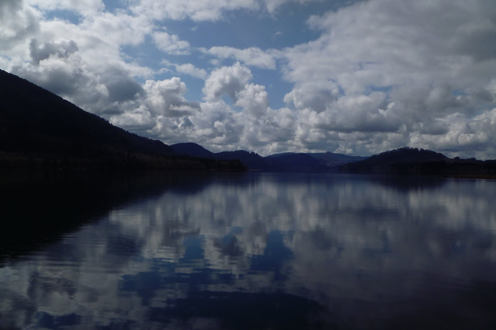

Coldwater Lake

The sun illuminates not only the eye of the man, but shines into the heart of the child. In the presence of nature, a wild delight runs through the man, in spite of real sorrows. - Ralph Waldo Emerson

Bank of Coldwater Lake


Coldwater Lake was formed by the eruption of Mt. St. Helens, when a debris dam penned Coldwater Creek. There are several similar lakes within the Mt. St. Helens Volcano Monument that were formed by debris dams. Scientists must keep a close eye on these lakes and their dams, as failure of the dams would produce mudflows comparable to or more devastating that the mudflow resulting from the 1980 eruption. As a result of this danger, "outflow channels" have been constructed to control the water level at Coldwater Lake (and others). 

Mt. St. Helens Behind
Coldwater Lake
Coldwater Lake sits at about 2,900 feet, low enough that there is no snow currently present. I wander the boardwalk path that takes one around the edge of the lake about a quarter mile. There is little access to the edge of the lake other than via this board path. I walk on around to the boat launch site, then over to the trailhead for a path that encircles the lake from the side of the mountain. It is too late to hike this trail, so I return.

Coldwater Lake
Rocks abound, not rounded rocks that have been smoothed by the effect of water flow over time, but jagged rocks. I don’t see any life in the lake, though signs indicate that it now teems with several species of trout. There are ducks and other birds resting on or around the water. Few people visit the lake while I am here, most of whom drive in and out quickly. Light snow begins falling again. I take my time. I want to savor this wilderness.

All too soon it is late enough that I know I must head north, to Seattle. I must work tomorrow. I stop multiple times on my way out of the Park, inhaling its beauty. I pass four deer on my way back to I-5. I think of the words of explorer George Vancouver

A Lifetime is not enough to explore this country, a man is too small to feel it’s size. The poet has not been born to sing its song, nor the painter to picture it.
No, a lifetime is not enough. But I will enjoy the rest of mine as I do my best to explore all that I can.

Donna
©April 19, 2011


Monday, April 25, 2011

Oregon Coast Day Two - Harbor Seals, Old Growth Forests, Clear Cutting, and Dunes - April 16, 2011


Harbor Seals
Yaquina Head Outstanding Natural Area
Yaquina Head Outstanding
Natural Area
I am out the door by 9:00am, headed to Yaquina Head Outstanding Natural Area. It is 49 degrees. Fog sits low and a heavy mist blankets the world. As I enter the park, I smile at its name. Apparently the person who named the park was pretty impressed by its treasures. I head first toward the lighthouse. The largest lighthouse on the Oregon Coast, it was first lit, I learn, on August 20, 1873 and is a functional light to this day, though now it is automated and no longer in need of attendants. Just below the lighthouse I discover steps that lead down to the rocky beach. Indeed, the beach is composed entirely of dark blue, almost black, oval rocks, called cobblestones. Some of the stones are as large as my fist. The rocks are composed of fine-grained basaltic lava, created when the lava was chilled and cooled quickly. I am delighted at my find.

Cobblestones
The fog is so thick that I cannot see very far. I note various shapes and sizes of sea stacks beyond the beach, but I cannot see far. Signs tell me that there are also tide pools in this area when the tide is low. However the tide is rising at present and I am unable to find any accessible pools. In the absence of a view, I am struck by what I hear instead. Above the roar of the ocean I hear birds calling. And as the waves ebb and flow, they jostle the cobblestones, which strike against each other, sounding somewhat like wind chimes that are made of both metal and wood, a quite pleasant tinkling sound.


I head down from the bluff to Quarry Cove. As I look across the cove, examining the broken vertical basalt that makes up the hillside, I am startled to see - harbor seals, reclining on rocks in the middle of the cove! Harbor seals! I am delighted. I have never before seen harbor seals. I am surprised at their coloring. I had always thought of seals as being dark grey or black. But these seals are varying light shades, and are spotted and mottled. They are quite funny looking, with short little fore-flippers, long heavy bodies, and short little feet set close together, looking barely functional.

I learn that seals, along with walruses and sea lions, are called pinnipeds, from latin words meaning winged feet. Harbor seals weigh 250 - 300 pounds. They have no ears, just round faces with large eyes. Closest to me is a rock upon which ten or so recline on their sides. As I watch, the water rises with the incoming tide, and they jostle for position. New seals climb on as some slide off. I can hear them talking, some making a groaning noise, some what sounds like a honk. I am fascinated.
 
I spend about an hour watching the seals - taking dozens of photographs as I do. There is no one present but me, probably a result of the early hour and the rain. The seals are aware of my presence, and one or two regularly gaze directly at me. But I am far enough way that they do not seem afraid. I am struck by the innocence in their faces. While watching them trying to position themselves on the rocks, I think that they must be among the most innocent, and most defenseless, creatures on the planet. I know they are quite agile in the water, I see them moving swiftly through the water even now. But they have no hands or feet which can grasp, and they cannot easily move while on land, can only bounce along on their bellies. Fortunately they are protected by the Federal Marine Mammal Protection Act. I change positions, take more photographs. A cream-colored seal continually checks back with me. I feel a connection taking place.
When we acknowledge that all of life is sacred and that each act is an act of choice and therefore sacred, then life is a sacred dance lived consciously each moment. When we live at this level, we participate in the creation of a better world. ~ Scout Cloud Lee
Seal Rock
It is now past 11:00, and I must move on. Just below Newport I find Yaquina Bay Lighthouse, followed by Seal Rock.. At Seal Rock, the sand is a deep orange color. The rocks jutting up are made of vertical slabs of basalt such as that which I had seen at Yaquina Head, though all seems to be crumbling.
  
Yaquina Bay Lighthouse
Just south of Seal Rock is Driftwood Beach, a wide sandy beach below some dunes. There are no rocky hills in this spot.  I am in a tsunami zone once again. I watch a very happy dog walk his people along this beach. I had been told that the coast was much prettier below Newport, and I am finding this to be accurate. I move on.


Driftwood Beach

Cape Perpetua - Cades
Cove Trail
Cape Perpetua - Devils' Churn

Soon I find Cape Perpetua Scenic Area and the Suislaw National Forest. At 800 feet, the Cape Perpetua Headland is the highest point accessible by car on the Oregon Coast. Sitka spruce forests can only grow within three miles of the coast, as conditions further inland are too hot and dry. Cape Perpetua is considered a rather unique ecological area as the temperate spruce rainforest transitions down to the sea. Trails take one from the parking areas along Hwy 101 down to the ocean as well as up to the top of the mountain.  I wander the Restless Waters Trail from the overlook of Devil’s Churn - where waves boil through narrow opening in the rocks - down to the beach, then pick up the Cave Cove Trail, a little over a mile and a half of hiking through a Sitka Spruce Forest. 

When I return to my car, I discover a road that spirals to the top of Cape Perpetua.  It is a ghostly drive through foggy forests. When I head back down, I notice a side road with a sign indicating "One lane road with turnouts." Oh, it is always hard for me to resist those one lane roads up and down mountains and through forests . . . The decision is made quickly, I turn left.  I find myself traveling through mixed countryside that brings a conflict to the fore and affects my ability to enjoy the areas of beauty I see.

Between sections of old growth spruce, Douglas fir, and Western hemlock I find myself driving through areas in which the forest was clear cut many years ago - and never re-planted. The hillsides are scarred, with stumps ranging from inches to a foot or more jutting from the ground. Short grasses or shrubs grow amid soil quite bare in areas. The hillsides are ugly.

I wonder why clear cutting? And why were the forests not re-planted? Who determined that savaging the land in such manner is okay. Seeing the land so damaged causes me pain. It hurts even worse as I drive through the old growth stands. Trees here are 150 feet or more tall. Trunks are massive. The undergrowth is thick and rich. White trillium are blooming.  The canopy stretches across the road, with trees intertwined. These are the trees which were cut.

White Trillium
I keep driving east, wondering where I’ll end up. I’m not sure exactly where I am. Signs at a trailhead indicate that I am on Forest Road 55. But my map does not show this road, so I’m not sure where I’m headed. The road turns from paved to gravel. Then the road worsens, as the dirt beneath the gravel is chewed up. My best guess puts me 8 or more miles from Hwy 101.

I keep going. I am curious. And soon I find myself in woods that are currently being harvested! Branches and small logs from cut trees are piled together, feet high. But it does not appear that in this area clear cutting is taking place. There are bare areas amid trees left standing. I am confused. I thought I would feel better. But I don’t, as I realize that the best of the trees, the largest, the most majestic are the ones which have been harvested. Complexity.

I begin to question our need for constant consumption of wood products, for lumber. I recall the many places I have visited, homes made of redwood and cedar. Is it worth raping the land in this way to have log homes? What about furniture? Complexity. I know from reading that these practices, both clear cutting and selective cutting, not only kill the trees but damage the land in various ways. They also affect entire ecosystems. Complexity. It hurts. I turn and head back. I need to seek out beauty once again.  But I know these questions will not leave me. I know I will be faced with these sites and these conflicts again, particularly over the next several days.

Cape Perpetua - Gwynn Creek
Just south I discover the Gwynn Creek beach area. This area is stunning, quite stunning. There are no people here. Where are all the people? I have the beach to myself, and I walk for a bit, savoring its beauty.

Cape Perpetua - Gwynn Creek


Then I discover Strawberry Hill Wayside, where I find more seals on rocky outcroppings. These are further away than were the seals at Yaquina Head. But I can hear them. I move on, and I discover Washburn State Park. I pass signs indicating elk can now be found in the area.

Heceta Head Lighthouse


Strawberry Hill Wayside
Harbor Seals


Humankind has not woven the web of life. We are but one thread wthin it. Whatever we do to the web, we do to ourselves. All things are bound together. All things connect.  ~Chief Seattle


I discover Heceta Head Lighthouse. The Heceta Head Lighthouse is purportedly haunted. Its ghost is Rue, wife of an assistant light keeper in the 1890's and mother of a young girl who drowned. Rue committed suicide and has haunted the Heceta Head Lighthouse ever since, looking for her lost daughter. Complexity.

Oregon Dunes National
Recreation Area
Just south of Florence I discover the Oregon Dunes National Recreation Area. This area is fascinating. According to educational material, the dunes stretch 40 miles from Florence to Coos Bay. Some dunes tower 500 feet above sea level. Though fifty years ago the dunes were bare, grasses have begun growing and the dunes are now comprised of mixed ecological areas.  On the east
Oregon Dunes National
Recreation Area
side of the dunes, a natural wetlands has begun developing.

Some areas in the park are open to offroad use of recreational vehicles. Some are closed, for foot traffic only. These are the largest expanse of coastal dunes in North America. I question, should we allow off highway vehicle use? Complexity. Five marked trails allow one to cross the dunes on foot to access the ocean. I hike up a trail to the top and survey the expanse. Once again, there are no people here. Where are all the people? It is not cold. It is no longer raining. The land is beautiful. I am fortunate to be able to see it like this.

I am exceedingly tired at this point and find myself bypassing parks, wanting to "bunk in" for the night. I think my fatigue is as much emotional as anything else. I am a bit overwhelmed by all the beauty I have seen, satiated at this point. I am overwhelmed by the amount of forest destruction I have seen. And I am overwhelmed by the complexity of the issues I have contemplated. I head to my hotel in Coos Bay and turn it all off for the night. I don’t even eat dinner, just crawl under the covers. Tomorrow is another day. I will start again.

Donna
April 16, 2011


Saturday, April 23, 2011

The Oregon Coast Day One - Wind, Rain, Seastacks, and Rainforests - April 15, 2011


Arcadia Beach

There are no easy answers. Not to most issues of substance, I think. I ponder this thought as I head across highway 26 from Portland to the Oregon Coast. I have been attending the annual conference of the American Association of Suicidology. At the last session I attended, researchers and clinicians addressed the question of predictability, i.e., can you accurately predict that someone will make an attempt to take his/her own life? What factors might provide clues that such an attempt is likely to take place? What factors might provide clues that such an attempt is likely to take place imminently. Some in the room expressed a desire to develop an protocol, an instrument, some standardized means of evaluation by which clinicians can predict that an attempt is imminent. I shake my head. I do not believe it is possible. Human behavior is not so predictable.  I agree that human behavior is somewhat predictable sometimes. I know that there exist lists of signs and indicators that someone might be suicidal. But I also know that some persons may exhibit such behaviors and yet make no attempt. And I know that some persons who take their lives exhibit no such signs. I appreciate the desire of these experts in suicidology to prevent such tragic loss of life. But I also know that we will never be able to predict with accuracy either way. Human behavior is a complex weave of internal and external factors, some of which we can never be in touch.

I will think further on these thoughts as I explore over the next couple of days. I had recently been apprised of the words of H.L. Mencken, "For every complex problem there is a simple solution . . . and it is wrong."  I agree with Mencken.  I know that the older I get the less black and white I see.  I have also discovered that I prefer color - in all its complexity - vivid color. Yes, let me see color!

I have five days to explore and plan to use every minute of it.  I have never before visited the Oregon Coast but have been told that it is quite magnificent. Many persons have told me that it is much more stunning than the Washington coast, which I love. I know that when I peruse the map, the Oregon Coast looks like it is composed of one state park or recreation area after another, down the length of the state. How many can I visit?

Road to Seattle Mountain Natural Area
It is raining as I head out, but I am not disappointed. I know that cloudy and rainy days offer photography opportunities that are limited by sunny ones.  I think on complexity. Some wish always for sunny days and curse the rain. But I know that it is difficult to photograph the forest on a sunny day - there is too much interplay of light and shadow to fully see . . . I know also that colors are more vivid beneath the clouds and the rain, that too much light washes out color. I welcome the clouds and the rain.
South Fork Rock Creek

As I drive west from Portland, I drive through rolling hills, farmland, orchards - and Christmas Tree Farms! Christmas tree farms always bring a smile to my face.  Soon I find myself in Northwest rainforest, dominated by coniferous trees, Sitka spruce, Douglas fir, Western and Mountain hemlock, Western red cedar, and Lodgepole pine. It is early spring and the hardwoods interspersed among the evergreens - maples and spruce - are only just beginning to bud. Because of the high annual rainfall, these woods are marked by mosses and lichen growing on tree trunks and a ground cover of fern. These are seriously tall trees!  I am anxious to be among them. I look for pullouts or parks that will give me an opportunity to wander among them, smelling, touching, and seeing.  

Skunk Cabbage
I see my first deer-crossing sign. Another smile. It is 11:15, and it is 40 degrees. I enter the Tillamook State Forest. I see my first snow at around 1500 feet, patches at the base of trees. I enter the Clatsop State Forest. Finally I find a rest area at Sunset Springs. This one has a trail that winds across the South Fork of Rock Creek and through the woods. I explore. The banks of the creek are lined by gnarly birch trees. Signs indicate that this area has been hit hard by fires in the past. The trees certainly look lush today.

I continue on. Soon I see signs for the Seattle Mountain Natural Area. I make the turn. The picnic area and mountain itself are 7 miles from Highway 26, on a one lane winding road. At least it’s paved. The road undulates and curves, and I am "forced’ to drive only 20 or so miles per hour. I drive through lush, lush forest. I can see in the distance some areas that have been logged, badly, where the ground looks ugly and scarred. I know I will face strong feelings about logging while I am out here. But for the moment I am under dense canopy, so I put those thoughts away. Complexity. I cross the Necanicum River. I pass areas of standing water in which grow the pretty but odiferous, yellow skunk cabbage. Hah! I know that the root of this plant is food for bears, who eat it after hibernating, as a cathartic or laxative. 
Necanicum River

Off the Road to Seattle Mountain
Natural Area
Finally I reach the end of the road, which is the trailhead for the path to the top of rocky Seattle Mountain. Though I sometimes hike alone, I trust my intuition, and this isolated area does not feel safe today. So I turn around and head back. I enjoy the drive. I am in my element. And I suddenly find myself slamming on my brakes and skidding across the road, to keep from hitting the doe who has bounded up the side of the mountain from my left, crossed the road, and headed into the forest to my right. I sit for a few minutes to let my heart rate return to normal. I smile. My first wildlife encounter of this trip. I am in my element. And I travel on. I am passed by only two cars on the 14 mile roundtrip into this forest.

Arcadia Beach
I finally reach the coast at Cannon Beach.  I am excited to explore this area which has been recommended by several people. But I am disappointed. The beach is flat and surrounded by houses, restaurants, and shops. It looks not much different from beaches on the east coast. I move on. And soon my expectations are gratified. First Tolovana Beach Wayside Park, then Arcadia Beach. Arcadia Beach is what I have been looking forward to! Vertical columns of rock called seastacks jut from the ocean floor. Rocky hillsides stretch down to the sea. Small caves are cut into the rock at the beach level. Mountains rise one behind the other along the coast to the south. Yes!

Arcadia Beach
 I move on. The rain has intensified. It is hard to see very far. I pass signs indicating that I am in a tsunami zone. These signs carry more meaning than they might at a different time. The road turns inland. I pass signs for Cape Lookout. But the coast is too far away to explore those beaches this afternoon. It is late and I want to spend the night in Newport. I pass dairy farms. And as I enter the town of Tillamook, I pass the Tillamook Cheese Factory and visitor center. I note its presence for a future visit. It has warmed a bit. It is 3:30 and is 52 degrees.
 

Boiler Bay
Highway 101 winds along the Pacific once again. Though visibility is limited by the rain, I turn into Boiler Bay State Scenic Viewpoint. As I exit the car, I am buffeted by high winds and pelted by rain. I learn that the area is named for a ship that sank in 1910, the J. Marhoffer. Apparently one can see the ship’s boiler at low tide. I would have thought the park had been named after the boiling action of the ocean as waves bounce off the rocky outcroppings.

Boiler Bay
I watch ocean swells move in, one after the other, not just waves but swells, the ocean rising as it reaches land. Though I am thoroughly soaked below my jacket, I wander the edge of the cliffs, just to see what I might see. I am rewarded as I find a cave next to a waterfall which plunges into the ocean. As I return to my car, I smile at the dozens of gulls and the handful of geese that have settled on the grass in the parking area. The wind is too stiff to fly, and these guys hunker down.

Rocky Creek State Scenic
Viewpoint

Now I find Rocky Creek State Scenic Viewpoint. Here the wind is so ferocious that I am hit by foam being blown up from the shore. I endure it happily. I laugh as I pull into Cape Foulweather. This spot was discovered by Captain James Cook on March 7, 1778. It is the first geographic location named by Captain Cook as he began his exploration of the Pacific Northwest. Apparently it is not unusual for winds of 100mph to buffet this area. I think Captain Cook must have been here on a day similar to mine. I move on.

I discover the Yaquina Head Outstanding Natural Area. I note that this park is operated by the US Bureau of Land Management. I note a lighthouse high on a bluff. And I see signs for a rocky beach. But the rain is too heavy and the wind too stiff to explore this park this evening. I will return tomorrow morning.

Yaquina Head Lighthouse
Yaquina Head is just north of Newport, my stop for the night. I check in to the motel. Then I ask the desk clerk to tell me what is the best local restaurant - not a chain - in the area. She directs me to Georgie’s Restaurant. I dine on shrimp at an oceanside table (indoor) and I reflect on the day. I still have four to go. They promise to be outstanding.

Donna
April 15, 2011©