Sunday, May 15, 2011

May 5, 2011 - A Day In the Life of a Family Promise Regional Director


Plans are to meet with a Family Promise of Volusia County (Florida) Board member in Daytona for lunch, then to head up to Bunnell for the first meeting of folks wishing to develop Family Promise of Flagler County.

Paynes Prairie


My morning route takes me south from Gainesville on Hwy 441, first past Paynes Prairie State Preserve, that sea of grass, sedges, and flowering plants whose wet lands harbor alligators, wild horses, bison, and a multitude of herons, egrets, ibis and other birds. I then roll through Micanopy toward McIntosh and Orange Lake, rural countryside dotted with alligator-laden lakes. Between Micanopy and McIntosh, I note signs for the homestead of Marjorie Kinnan Rawlings, author of The Yearling. This is the sandy soil of which she writes.

Orange Lake
It seems to me that the earth may be borrowed but not bought. It may be used but not owned. It gives itself in response to love and tending, offers its seasonal flowering and fruiting. But we are tenants and not possessors, lovers and not masters. Cross Creek belongs to the wind and the rain, to the sun and the season, to the secrecy of seed, and beyond all, to time. ---Marjorie Kinnan Rawlings, Cross Creek
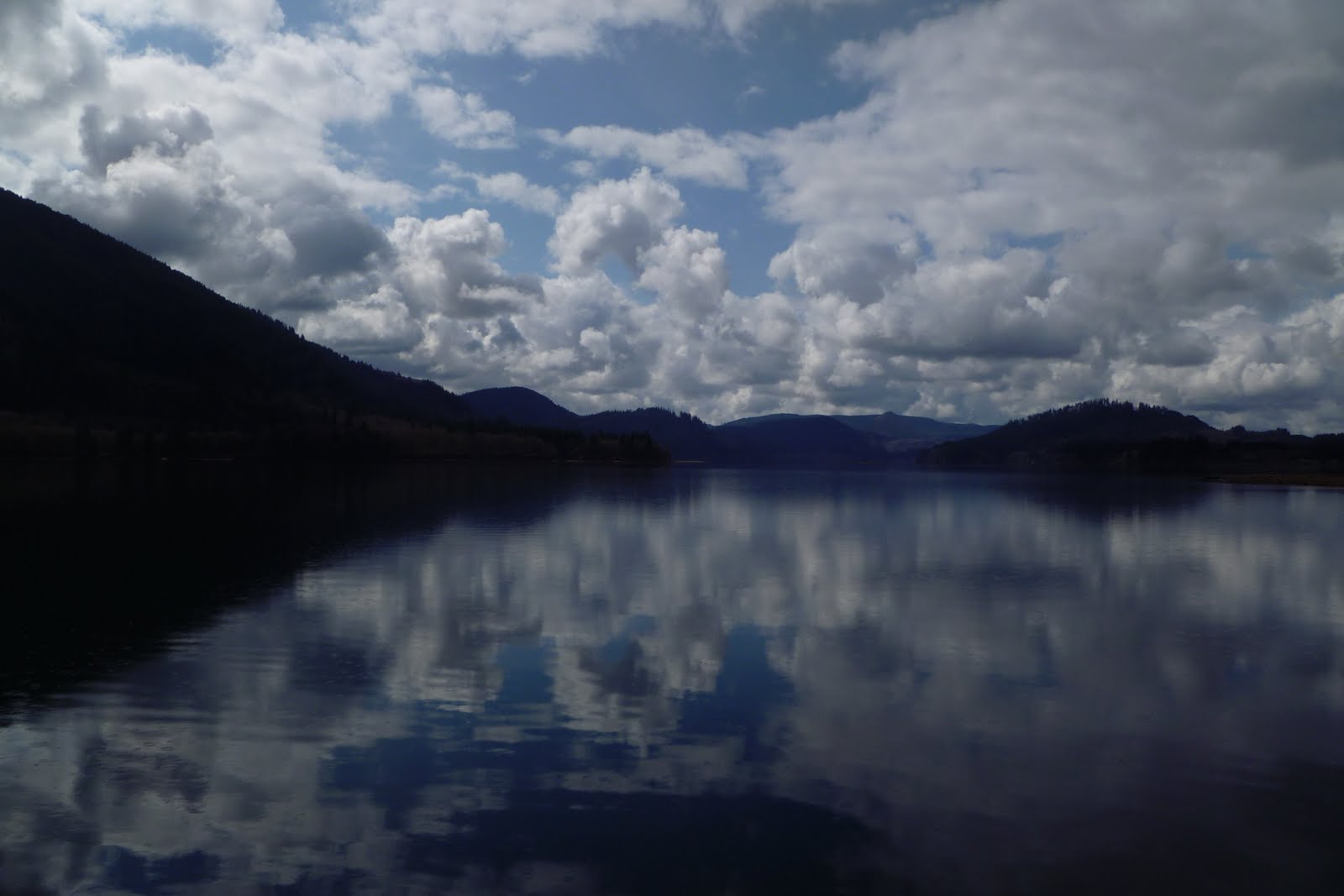
 
I think, I wish I could write like Marjorie. I do like the things she thinks about.  I think on the land as I drive on. Soon I’m in Marion County, in the midst of beautiful horse farms on rolling green land. Foals cavort in the fields as I drive by. I wish I had time to stop and watch for a while. 
Marion County Horse Farm

Who knows, I could see a future Triple Crown winner testing his legs! Instead I take a bypass around Ocala and head east on Hwy 40, through the Ocala National Forest, the southernmost forest in the continental United States. 

The Ocala National forest is the world’s largest contiguous sand pine scrub forest, high dry sandy ridges of pine and palmetto rich in water, including more than 600 creeks, lakes, rivers and springs. Signs warn to watch for bears and deer crossing the road. I've seen deer in the past, as well as lanky sandhill cranes, but never a bear. I pass through small crossroads of convenience stores, gas stations, and mobile homes clustered around small lakes. The land becomes more isolated and soon there are few signs of civilization. I stop at Wildcat Lake. The sky is blue, the lake is blue, the trees are green. It is a beautiful day in the forest!
Wildcat Lake, Ocala National Forest
I do not know how any one can live without some small place of enchantment to turn to.
Marjorie Kinnan Rawlings

Fern Farm

I breathe, take a few photographs and move on. Just past Astor are the fern farms, row after row of tropical greenery thriving under translucent tents. Soon I find myself in Barberville, the intersection of Hwys 40 and 17.
 
Barberville Fruit Stand

This small community always makes me smile. Its landmark (for me) is the garish Barberville Roadside Fruit Stand, which sells much more than fruit - including bright yellow metal sunflowers, colorful imported pots, and tall, bright statues . . . of dinosaurs, chickens, horses and various and sundry other .... critters. I should stop some time and check out the quality of its wares. For now I just smile and move on.

Daytona Speedway
In short order I am in Daytona. I am scheduled to meet Audrey at a restaurant located across from the Daytona Speedway, home of the renowned Daytona 500 NASCAR race. I am a bit early, so I stop to take a few photographs of the Speedway. Though I normally prefer wild places, this edifice fascinates me. The track is a 2.5 mile "trioval." I’m not quite sure what a trioval is, but I do know that the track is enormous.
There is a 29 acre lake in the infield! Because of the diverse schedule of races held at this speedway, it has earned the name World Center of Racing. I smile at the photos of drivers adorning the track supports, then head over for my meeting with Audrey.

After a warm, long lunch with Audrey and updates on Family Promise of Volusia County, I head up I-95, then exit west onto SR 100 at Palm Coast. Flagler County is composed of three distinct communities, Flagler Beach, Palm Coast, and Bunnell. Flagler Beach, known for its orange-colored sand, is sandwiched between the beaches of St. Johns County to the north and Volusia County to the south, both of which allow cars to drive on the beach. I personally prefer unmotorized beaches, which is one of the reasons I appreciate Flagler Beach (which even has a stretch sans buildings that runs alongside A1A). When I drive through Palm Coast I think of new Florida, subdivisions of ranch-style homes set amid thick lawns of St. Augustine grass. Palm Coast and Bunnell are connected by a corridor of pine trees and modern strip mall.

Bunnell, population less than 5,000, represents old Florida to me. Indeed, descriptions of the county report that Bunnell is one of the oldest communities along the east coast of Florida. The town is named after Alvah Bunnell, who established a small cypress shingle mill in the area in the late 1800s. The abundance of pines allowed for growth of turpentine businesses in the area as well. Town is composed of low rise, historic buildings of stone, red brick, and wood. A source of pride is City Hall, erected in 1936-37 and built of coquina, that soft, white Florida rock composed of crushed marine shells and coral. As I enter from the east I am greeted by a stereotypical name-emblazoned water tower. Its been several years since I’ve been through Bunnell, and I am surprised to note the large, modern county government building.

After dinner with Jim and Jackie, who are spearheading the Family Promise development efforts in Flagler County, we host a meeting at First United Methodist Church of folks from the community who are interested in developing a Family Promise affiliate. This community has a strong interest in serving homeless persons, and there is much excitement in the room. By the time we’re finished, violin-playing Father Al from Santa Maria del Mar Catholic Church has invited everyone to attend the next meeting at his church, which will include an italian dinner cooked by Father Al himself!

Satisfied with a day that included interaction with numerous good-hearted folks as well as drives through intriguing countryside, I soon turn toward home. I take Hwy 100 west toward Palatka, through farms of cabbage and potatoes and across the St. Johns River. Then I head on in on through more sandy pine forest interspersed with ponds and lakes. It is late by now, quite dark, and I content myself with thinking of this day, as well as times past. I have held jobs before that confined inside buildings all day. Those were difficult days. I am grateful for a job that allows me to traverse the countryside while working with good people at a good and necessary task. Though the land I traveled today may not include mountains and cliffs, it has its own beauty, or as Marjorie describes, it’s own enchantment.
Enchantment lies in different things for each of us. For me, it is in this: to step out of the bright sunlight into the shade of orange trees; to walk under the arched canopy of their jadelike leaves; to see the long aisles of lichened trunks stretch ahead in a geometric rhythm; to feel the mystery of a seclusion that yet has shafts of light striking through it. This is the essence of an ancient and secret magic. --Marjorie Kinnan Rawlings
I close the day tired, but content.

Donna


©May 5, 2011
Photos of Marjorie Kinnan Rawlings' Homestead in Cross Creek
Barn


Main House


Inside Barn

  
Marjorie's beloved orange trees

House for Caretakers


Pacific Northwest Day 5 - The Problem of Mt. St. Helens - April 19, 2011


Humankind has not woven the web of life. We are but one thread within it. Whatever we do to the web, we do to ourselves. All things are bound together. All things connect. ~Chief Seattle, 1855
To Mt. St. Helens or not? That is the question. It has been four good but long days in the Pacific Northwest, a long nine days of travel total. I’m feeling fairly tired. I think I should head straight to Seattle, check in to my hotel, and relax for the afternoon. . . . But there’s the problem of Mt. St. Helens! I’m tired - but Mt. St. Helens is only about fifty miles from the interstate. . . . I think I’m worn out. But the mountain is sooo close, and the sky is turning blue . . . How about if I pack up and get in the car and then decide? Okay. Ahh, it’s a no-brainer. It’s so close, how can I give up the chance to see Mt. St. Helens? I head out.

Lewis River at Merwin Park
There are two routes from I-5 to Mt. St. Helens. According to material I’ve read, the southern route, across Hwy 503, is the more scenic route, the one that travels through forested land and will eventually take me to Ape Cave and Lava Canyon, and on around and up to Windy Ridge and Spirit Lake, the closest points to the mountain itself. So it’s decided, I take 503. Though the fog is lifting and the sky is blue overhead, I note that the sky above the mountains to the east is totally covered in clouds. I recall it being said of the tall mountains that they create their own weather. For that reason, one can never know if the sky will be blue. I have been cautioned that I likely will not see the mountain. But there’s a chance. And it’s only 50 miles off the interstate. I head east.

Lewis River, Yale Reservoir

 
I very quickly find myself in forest, and note that the road is paralleling the Lewis River. This river originates on the western slope of Mt. Adams in Washington, flows south of Mt. St. Helens, and terminates when it flows into the Columbia River. I learn that the river was named after A. Lee Lewis, an early settler who homesteaded near the mouth of the river. I need to get close to the water, so I begin looking for parks or other means of river access. I see signs for Merwin Park, and I turn off.  When I arrive at the entrance to the park, I am surprised to learn that it is not a state or federally owned park, rather is owned by Pacific Corp, an electrical energy company. Pacific Corp controls various dams and hydro-electric plants on the Lewis River, and they have created parks and recreational facilities for public use. I think, that’s very nice. But I wonder what I don’t know that might make me think otherwise. Oh, sounds so cynical! Actually, I know it is just a recognition of complexity. In any event, I find my way to the edge of the river. It is wide and flat and gray today. I take some photographs, and wander on.

Soon I learn that my cynicism was for good cause. I pass a multitude of signs along the road that state "No Way BPA," I learn that there are plans to erect high voltage power lines in this area, and that residents have banded together in protest.. . . . Complexity. I find myself hopscotching from Pacific Corp park to Pacific Corp park along the Lewis River. I stop at Speelyai Bay and Yale Reservoir. I learn that the Lewis River is home to the Bull Trout, and there are fish hatcheries located next to some of the parks.
 
Temperatures are falling. By 11:00 a.m. it is 36 degrees and snow has begun to fall lightly. These are tiny, hard pellets of dry snow. Does this constitute sleet? I don’t know. I’m from Florida and don’t know these things. I finally reach an entrance to the Mt. St. Helens National Volcanic Monument and I drive on in. But I am disappointed to discover that just beyond this entrance, the roads to Ape Cave, the Climbers Bivouac, and Lava Canyon are closed, because of snow! I had no idea there was this much snow still on the mountainsides. I am disappointed. My maps had indicated that there are a number of waterfalls just beyond where the road has closed. I was looking forward to exploration. Instead I turn around and head back toward Hwy 90. 
Inside Mt. St. Helens National
Volcanic Monument - Badly
"Harvested" Forest


I stop on the side of the road and walk out into a snow-covered field. The snow is so deep that I can only do so by walking in the steps of those who blazed the "trail" before me, prints that are 6 inches deep. In the distance I can just see the base of Mt. St. Helens; the top of the mountain is covered by clouds. In the distance I see odd-looking mountains:  there was once a stand of trees that has been clear cut, creating patches of total white amid still-forested areas. I frown. Then I realize that I, too, am walking where there was previously a forest. My steps take me around stumps of the trees that once were. I am pleased when I see small new trees jutting up out of the snow. 
It was strangely like war. They attacked the forest as if it were an enemy to be pushed back from the beachheads, driven into the hills, broken into patches, and wiped out. Many operators thought they were not only making lumber but liberating the land from the trees.   — Murray Morgan, The Last Wilderness
Swift Reservoir

I continue to head east on Hwy 90, which now runs just north of and above Swift Reservoir. The water has that blue-green caste that you see in areas of heavy snow runoff and glacial melt. I would like to touch the water, but at this point I don’t see any access sites. I am deep in isolated forest land which, as always, warms my heart.

However, soon I receive a major disappointment. As I reach the junction of Hwys 90 and 25, signs indicate that Hwy 25 is closed ahead! I am crushed. This is the road that accesses Windy Ridge, the closest point to Mt. St. Helens. And it is the only way "out of here," short of my returning the way I came. I stop at the Mt. St. Helen’s Visitor Center to see if there’s another way in or out, but the Visitor Center is closed. I have no choice. I turn around.

I am feeling a bit ticked off! Having made the decision to visit Mt. St. Helens, I am seriously unhappy to have my plans thwarted. It is noon at this point, half the day is gone. But I decide that I will not give up, I will head back to I-5 and take the northern road, Hwy 504, into Mt. St. Helens. I figure I have about a two hour drive before I reach the northwest entrance to the park. But there will still be daylight, I will still see the mountain (assuming, of course, that the weather cooperates). As I head back, I probably drive much faster than I should on these winding mountain roads. It takes about an hour to reach I-5. It is raining steadily by now.  


Mt. St. Helens and North Fork
of the Touttle River from
Hoffstadt Bluffs Visitor Center
Soon I reach the exit for Hwy 504 and head east once again. I discover that the terrain is much different on this drive than was my southern route. While my previous route had me driving through forest, up under tree cover, I now find myself driving through valleys with tremendous views of the countryside. I begin to parallel the North Fork of the Touttle River. I catch my first glimpse of Mt. St. Helens across some wetlands at the Silver Lake Visitor Center. The clouds seem to have dispersed a bit. I am hopeful . . .

The Blast Zone
I stop at the Hoffstadt Bluffs Visitor Center and learn a bit more about Mt. St. Helens and the effect upon the land of the eruption on May 18, 1980. Here at the Visitor Center I am looking down at the valley floor, through which runs the Touttle River.  
Touttle River Valley
Staff tell me that the road I have been driving ran through that valley as well - before the eruption. However it and all of life below us was covered by "volcanic debris" to an average depth of 150 feet when the eruption began and the north flank of Mt. St. Helens collapsed, creating the largest landslide-debris avalanche in recorded history. The debris avalanche was about 24 square miles in area and advanced more than 13 miles down the North Fork of the Touttle River.
  

Just subsequent to the collapse of the north flank, an explosion referred to as a "lateral blast" of rock, ash, and hot gases exploded upon an area of about 230 square miles, north of the volcano, in a fan-shaped vector. Scientific calculations indicate that the blast ranged from an initial 200 mph up to approximately 670 mph. As far as 19 miles from the volcano, forests of trees as tall as 100 feet high were flattened in seconds. Shortly after the lateral blast, a vertically-directed column of ash and steam exploded from the volcano, reaching an altitude of more than 12 miles.

Mt. St. Helens and the Touttle
River Valley
 By 11:45 am, a little more than 3 hours after the initial collapse of the north flank of Mt. St. Helens, an ash cloud dense enough to block out all sunlight reached Spokane, Washington. The intense heat, melted snow and ice, and debris from the explosion created an immense mudflow that ran rapidly down the Touttle River Valley, knocking down trees and destroying everything in its path. The mudflow eventually reached the Columbia River, filling its channel and stopping ship traffic. By early May 19th, the eruption had stopped. Mt. St. Helens was 1,314 feet shorter after the blast. It now stands at 8,363 feet tall.

I leave the Visitor Center and travel on. Roadside educational exhibits document reforestation efforts. More than 150,000 acres of forest in a 234-square-mile arc were devastated by the eruption of Mt. St. Helens. The affected lands were owned variously by Weyerhauser (68,000 acres), the US Forest Service (64,000 acres), the Washington State Department of Natural Resources (12,000 acres) and other private land owners (6,000 acres). The forests consisted of western hemlock, western red cedar, and several species of fir. Oddly, much of the downed timber was still useable, but in danger of damage due to insects and disease if not salvaged.

Replanted in 1983
Within months after the eruption, Weyerhauser began salvage logging, followed by hand planting of 18.4 million seedlings, douglas fir at lower elevations and noble fir at higher elevations. Trees planted after the blast now stand 70 feet tall. Other species have re-grown on their own, include hemlock, western red cedar, alder and maple. Research has shown that the salvage and re-planting efforts helped to renew the land, by mixing volcanic ash with mineral soil, which allowed rain water to penetrate the soil rather than running off the crusted ash surface.

Though Weyerhauser engaged in reforestation efforts on their privately-owned land, the US Forest Service made the decision not to harvest or re-forest, rather to allow natural activities to take place. In 1982, the 110,000 acre Mt. St. Helens National Volcanic Monument was established. Inside the monument, no salvage and no tree planting were allowed. Today the "blow down forest" has virtually disappeared. I learn that the weight of snow packs each year has pushed tree trunks into the ground and soaked the trees while summer sun subsequently bakes them. The result is a rapid deterioration of the trees. At the same time, wind-blown seeds caught by the moist, nutrient-rich tree trunks have established an area of low-lying grasses and shrubs, that has allowed other growth to take place. 

I have clear views of Mt. St. Helens at this point, and I note with a big smile that the clouds are lifting, and the sky is turning blue! I can see the mountain, in all her glory! And she's beautiful!  Then I enter "The Blast Zone," the area directly affected by the explosion in 1980. It is about this time that I note that there is steam issuing from the crater of the volcano, and I realize that this is still an active volcano. This realization, together with the signs indicating that I’m in the blast zone, simultaneously give me a chill and a thrill!

As I head on toward the mountain, I travel through areas of green, re-planted forest while also viewing less lush areas of growth in the zone that has not experienced re-planting. I am pleased at the re-planting and re-growth. But I note that the re-planted forest has an odd look to it. I realize that this is because there is little to no understory. Natural, undamaged forest has an understory, some thick with ferns, flowers, and other plants, some less dense, depending upon the part of the world in which it is located. But I see little growth under these trees. I guess it will take more time for this type of growth to occur.

I travel on. Soon the land and trees around me are snow-covered. In fact, it begins to snow intermittently, a light snow that does not stick to the road. I am at 3,800 feet in elevation. Notwithstanding the falling snow, the clouds around Mt. St. Helens continue to dissipate, and I am treated with several hours of good views, "Oh Wow!" views. Oh Wow! There are few cars on the road. I think I have seen perhaps 6-10 cars going in either direction. I guess it’s too early in the season for most folks to think about visiting. That’s fine with me. I enjoy the solitude amid the great beauty of the wild. I stop on the road multiple times to take photographs. I soon learn that the road is closed once again, at the junction of Hwy 504 and the road to Coldwater Lake. I cannot get up to the Johnston Ridge Observatory. But I can access Coldwater Lake.


Coldwater Lake

The sun illuminates not only the eye of the man, but shines into the heart of the child. In the presence of nature, a wild delight runs through the man, in spite of real sorrows. - Ralph Waldo Emerson

Bank of Coldwater Lake


Coldwater Lake was formed by the eruption of Mt. St. Helens, when a debris dam penned Coldwater Creek. There are several similar lakes within the Mt. St. Helens Volcano Monument that were formed by debris dams. Scientists must keep a close eye on these lakes and their dams, as failure of the dams would produce mudflows comparable to or more devastating that the mudflow resulting from the 1980 eruption. As a result of this danger, "outflow channels" have been constructed to control the water level at Coldwater Lake (and others). 

Mt. St. Helens Behind
Coldwater Lake
Coldwater Lake sits at about 2,900 feet, low enough that there is no snow currently present. I wander the boardwalk path that takes one around the edge of the lake about a quarter mile. There is little access to the edge of the lake other than via this board path. I walk on around to the boat launch site, then over to the trailhead for a path that encircles the lake from the side of the mountain. It is too late to hike this trail, so I return.

Coldwater Lake
Rocks abound, not rounded rocks that have been smoothed by the effect of water flow over time, but jagged rocks. I don’t see any life in the lake, though signs indicate that it now teems with several species of trout. There are ducks and other birds resting on or around the water. Few people visit the lake while I am here, most of whom drive in and out quickly. Light snow begins falling again. I take my time. I want to savor this wilderness.

All too soon it is late enough that I know I must head north, to Seattle. I must work tomorrow. I stop multiple times on my way out of the Park, inhaling its beauty. I pass four deer on my way back to I-5. I think of the words of explorer George Vancouver

A Lifetime is not enough to explore this country, a man is too small to feel it’s size. The poet has not been born to sing its song, nor the painter to picture it.
No, a lifetime is not enough. But I will enjoy the rest of mine as I do my best to explore all that I can.

Donna
©April 19, 2011