 |
| Acadia - Schoodic Point |
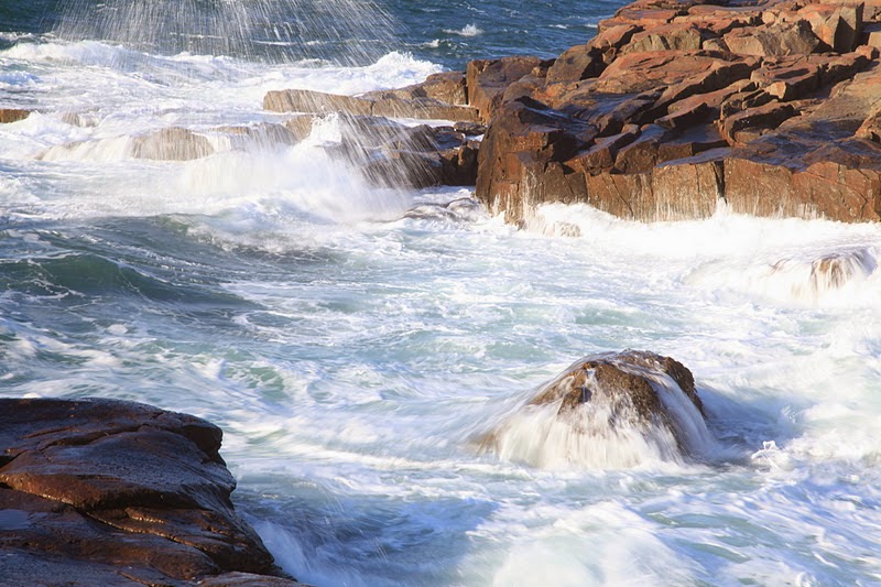 |
| Acadia - Schoodic Point |
The ice that had covered the water in the inlet has melted. It feels a bit warmer than yesterday, though the wind is blowing fiercely. Waves are pounding the rocks, and the surf is flying through the air. I spend more time at Schoodic Point, scrambling out on the rocks, working the scene from every angle.
 |
| Acadia - Schoodic Peninsula |
The difference of about two hours gives me a different “view” of the land than yesterday, and I am able to capture some scenes that I could not before, because of the angle of the sun. I attempt to get down closer to the water than I did yesterday, however the spray from the sea soon coats the lenses of my cameras, and I must move further up the rocks.
 |
| Acadia - Arey Cove |
I head on around to Arey Cove, to the spot of beach that is composed of cobblestones and smaller rocks. I love this spot. Because the cove is sheltered, I am not hit by the fierce winds that blew off the Point. The waves washing gently up onto shore cause the rocks to knock lightly against each other, creating a magical tinkling sound. It reminds me of the beach at Yaquina Head Natural Area, north of Newport, Oregon. I wander along the water’s edge and play amid the stones for a bit. I spend about an hour in Acadia then head back out through Winter Harbor to U.S. 1. I stop long enough along the way to take a quick photograph of some of the stacks of traps in a yard. I note the name of one of the boats, Easy Come, Easy Go.
 As I travel north, I am struck once more by the bleakness of some of the landscape. I’m sure winter plays a part, given that there are no leaves on the hardwoods. But I have also seen the landscape described similarly in tourist literature, “over 200,000 acres in the vast barrens of low-bush wild blueberries.” In some places the land reminds me of the salt marshes in the southeast. At East Machias I take a detour down a finger, Route 92, headed toward Machiasport. I pass even more homes with boats and traps in the yard. Some are nice homes on larger lots of land, some are small homes, no more than shacks. But the presence of the boats and lobster fishing paraphernalia is pervasive. I am most definitely in lobster country. What I find most interesting is that I don’t see any” lobster pounds,” those restaurants peculiar to Maine that one finds throughout Mt. Desert Island and along the coast as one drives south - where one can dine on fresh lobster by the pound. I see very few restaurants of any kind as I drive north, and definitely no lobster pounds. Interesting.
 |
| Jasper Beach |
Soon I reach my destination, Jasper Beach. Jasper Beach is a crescent shaped, gravel beach located on Howard Cove. Tourist information I read last night described Jasper Beach as one of only two beaches in the world made of jasper. I learn that this information is incorrect. Though the rocks are red and resemble jasper, they are fine-grained volcanic rock called rhyolite. The shore here is protected by the cove, thus there is little wave action.
 |
| Jasper Beach |
The gentle movement of the surf has polished the rocks and rounded them. The beach is about half a mile long and totally deserted. It is not as pretty as Schoodic Peninsula, but it has its own beauty, and I am satisfied with my find.
 |
| West Quoddy Point Lighthouse |
I head back to East Machias, up U.S. 1 a bit, then take another detour down Hwy 191. More travel through even less populated land brings me to the outskirts of the town of Lubec, then to my destination, the West Quoddy Point Lighthouse. The lighthouse was named for the Passamaquoddy Indian Nation. This quaint, red and white striped lighthouse is renowned for its location, on the easternmost point of the continental United States. Across Quoddy Narrows is Grand Manan Island, Canada. The Park that is home to the lighthouse is closed, and the area is deserted. Once again, it’s just me.
 Though I cannot drive my car into the Park, I can walk in. I wander the grounds with my camera, and I smile to myself and engage in reverie. In 2005 I visited Anchor Beach, Alaska, the westernmost point of the United States that is on the continuous road system. I had visited the southernmost point at Key West, in 1978. In 2010 I visited Cape Alava, Washington, the westernmost point of the contiguous United States, located in Olympic National Park and the Ozette Indian Reservation. I have now stood at eastern, western, and southernmost points! I wonder to myself where will be the northern exploration. . . . Then the foghorn sounds and I move on.
 |
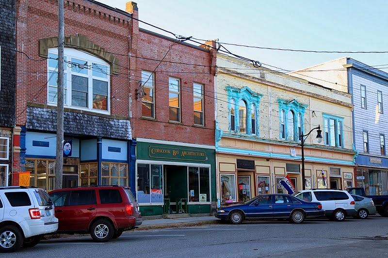
| Lubec |
My explorations have taken time, and I begin to worry that I will not reach Eastport until dusk, so I head on out, passing through the town of Lubec. Lubec is one of the communities of which Mick spoke when he spoke of the struggles of the people. From what I understand, Lubec was once a sardine packing capital of the world. With more than twenty canning factories and a can-manufacturing plant, the community was prosperous. The loss of the sardine-canning business in the 1960's was the downfall for the economy.
 |
| Lubec |
Lubec is a point at which Americans can enter Canada, across the International Bridge to Campobello Island, therefore there is some income from tourism. However, this is not enough to sustain a healthy economy. Though tourist sites tout new “industry,” such as sea salt making, sea urchin and sea cucumber harvesting, and salmon farming, as I ride through town I see evidence of the difficulty the community has experienced. Numerous pretty, shingle-sided buildings stand empty, shingles weathered with age and wear. Few cars are on the streets.
 |
| Lubec |
 |
| Eastport - Main Street |

As I wander through town, I see evidence of the poverty, of which Mick spoke, of which Terkel wrote. Eastport is the Easternmost as well as the deepest deep water port in the United States. Its proximity to Europe and the depth of the water would seem to portend good things for its shipping industry.
 |
| Nature's Grace* |
Funds have been allotted to Eastport to rebuild the waterfront, which now has a large cargo pier from which freighters load cargo for shipment overseas. Indeed, last evening the owner of a local art store told me that the 3 young men who were wandering the street ahead of me are crew on a Dutch ship that will be sending pregnant dairy cows to Turkey, to help re-establish the Turkish herds. However, a lack of rail service hinders the community’s ability to garner lucrative business in an industry that needs rail access, and the port is underused.
I wander through town by car and on foot. I smile at the two sculptures on the waterfront off Main Street.* I smile when I learn how the town observes the ringing in of the new year - by dropping a giant sardine and a maple leaf from the top of one of the historic buildings downtown.
 |
| Eastport |
 |
| S.L. Wadsworth & Sons Ship Chandlery |
I briefly visit S. L. Wadsworth & Son, known as both the Nation’s oldest ship chandlery and Maine’s oldest retail business. Though the store no longer sells harpoons and whale oil, it does sell marine items, hardware, and nautical gifts.
 |
| Eastport |
Then I stand at the edge of the pier and gaze far off into the distance. I am determined to see it, the Old Sow! Old Sow is the largest whirlpool in the western hemisphere, the second largest in the world. It is called Old Sow because of the noise that is made by the churning of the water. Old Sow is located in the Western Passage of Passamaquoddy Bay. According to the Old Sow website, “40 billion cubic feet of water floods into Passamaquoddy Bay with each incoming tide and mixes with the countercurrents from the St. Croix River to the north of the bay.

 There's a 400-foot-deep trench to the southwest of New Brunswick's Deer Island Point that continues as a 327-foot trench to the northwest. Bisecting the trench is a 281-foot undersea mountain. All that water flooding into the bay has to negotiate a right-angle turn to get around Deer Island Point, and then it slams into that undersea mountain. When heavy winds coincide with especially high tides, it becomes liquid chaos and disaster for the unwitting seafarer” - Old Sow. According to the site, one can purportedly see Old Sow from the shore of Eastport. It is beginning to get dark, so my ability to see into the distance is limited. But briefly, I swear, there it is, I see it! I think I see it, maybe . . .
  |
| Passamaquoddy Bay |
Donna
©December 2011

*The two pieces of art in Eastport have an interesting history. The colorful fisherman was built for the filming of a 2000 FOX reality series, Murder in Small Town X, which had ten contestants. The winner was a firefighter in New York City, who was killed when the Twin Towers fell. The community purportedly left the statue standing, in his honor. Eastport was chosen as a recipient of the 9 1/2 foot tall sculpture Nature's Grace from the Schoodic International Sculpture Symposium. Created by artist Jim Boyd of Hampton, New Brunswick, the sculpture depicts a sail and a large leaf with a fish.


